Alaska”]
The Northernmost National Park in the United States.
Gates of the Arctic National Park
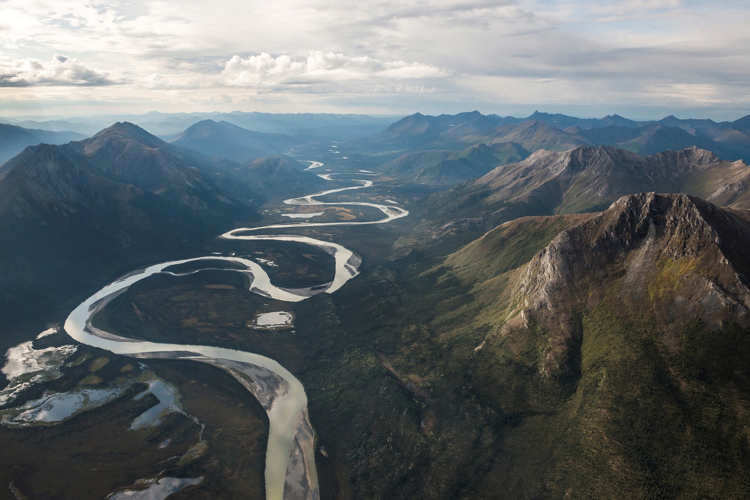
Gates of the Arctic National Park and Preserve is the northernmost national park in the United States, located entirely within the arctic circle. It is one of the least visited national parks with no roads inside its boundaries. It is primarily composed of the Brooks Range, an extension of the Rocky Mountains in Alaska. When combined with the Gates of the Arctic Wilderness and the adjoining Noatak Wilderness Area, the parks are the largest contiguous wilderness in the United States. The Gates of the Arctic National Park and Preserve is the second largest national park at nearly 8.5 million acres. The only national park which is larger than Gates of the Arctic is Wrangell-St. Elias National Park, which protects 13.2 million acres. Denali sits below it at third with around 6 million acres.
Gates of the Arctic was named America’s second worst national park by Fox News in 2015, but that makes us love it even more. If you want to have all of the comforts of modern civilization, including your car, there are plenty of parks in the Lower 48 States for you. If you want to get into the Alaskan wilderness where there are no roads and no human made trails, this is the place for you.
Open / Close / Reopening Status of Gates of the Arctic National Park due to Coronavirus (COVID-19)
More information on Gates of the Arctic
Last Updated: May 2, 2020
 History
People have lived in the Brooks Mountain Range for over 13,000 years, and there are thousands of archaeological sites throughout the area to document what was left behind. Ancient populations were small and constantly on the move, harvesting whatever was available in that season. In the last century, people settled in permanent, year-round villages, and today there are eleven communities associated with the park, whose residents use subsistence within and nearby the park to survive. The first Europeans arrived in the 1880s, starting with military explorers assigned to explore and chart the frontier. Prospectors followed in search of gold, triggering a gold rush in 1898, and scientists to examine the natural and cultural history of the area. Finally, those in search of recreation came to conquer the rugged terrain.
Gates of the Arctic was first declared a U.S. National Monument in 1978. In 1980, it became a U.S. National Park as part of the Alaska National Interest Lands Conservation Act.
The Name
The Gates of the Arctic is a reference to the Frigid Crags and Boreal Mountain, which are split by the Koyukuk River. They got this name from Bob Marshall in 1929. Robert (Bob) Marshall was a wilderness activist that co-founded the Wilderness Society in 1935. He was born in New York City in 1901 and took his first trip to Wiseman, Alaska in 1929. The Wilderness Society website describes it as the “beginning of a love affair with the Central Brooks Range in the Alaska wilds.” He was a US Forest Service forester and the inspiration for the creation of the national park.
Frigid Crags and Boreal Mountain stand on opposite sides of the North Fork Koyukuk River. The North Fork of the Koyukuk River is 102 miles long flowing from the south flank of the Brooks Range and Mt Doonerak to Bettles and its confluence with the John River. The 5-7 day float trip down the North Fork of the Koyukuk River through the park is a popular option for visitors. It can be done with kayaks or rafts and contains many Class I rapids. It has the added benefit (for some) of not requiring a second bush plane flight since the North Fork flows through Bettles.
Entrance fees
There are no fees to enter the park, although getting there (airfare etc) may require fees.
Arctic Circle
The Arctic Circle is the northernmost of the five major circles of latitude on maps of Earth. It marks the location where the center of the sun is visible at noon on the December solstice and the center for the midnight sun is visible on the summer solstice. For those north of the line (as is anyone in Gates of the Arctic National Park), they experience a full day of sun for at least one day in the summer and a full day in the winter where the center of the sun does not rise above the horizon. The position of the Arctic Circle depends on the axial tilt of the Earth, and is shifting north.
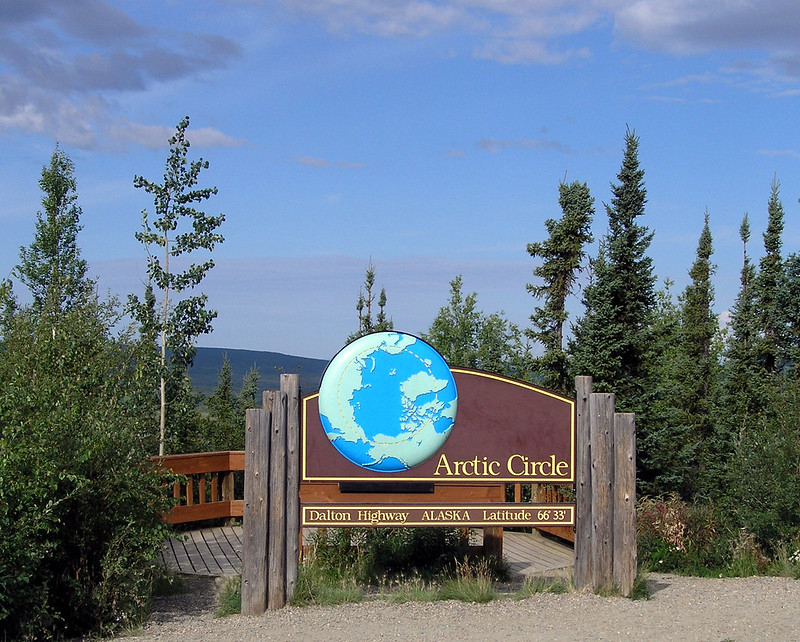
The sign pictured above is located along Dalton Highway (not in the national park).
Brooks Range
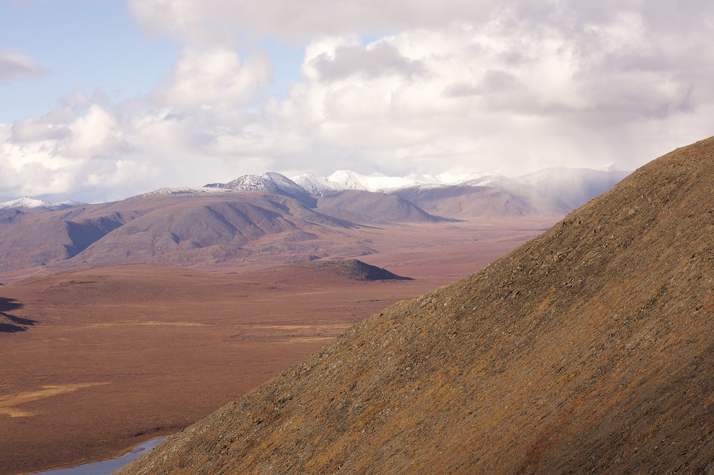
A defining geological characteristic of the park is the Brooks Range. It is the northernmost extension of the Rocky Mountains in Alaska running through the park as its stretches from the US-Canada border across the state more than 600 miles to the Chukchi Sea with widths up to 200 miles. It is named for Alfred H. Brooks, an American geologist that served as the chief geologist for Alaska for the US Geological Survey in the early 20th century. The portion that runs through the park is frequently called the central Brooks Range.
Mount Igikpak is the tallest mountain in Gates of the Arctic National Park and is also the highest peak in the Schwatka Mountains region of the Brooks range. It is located in the southwest corner of the park near the headwaters of the Noatak River and west of the Arrigetch Peaks. It has an elevation of 8,276 feet.
The Arrigetch Peaks are granite spires in the central Brooks Range that reach to an elevation of 7,192 feet near the Alatna River and at the headwaters of the Kobuk River.
Mount Doonerak reaches to an elevation of 7,457 feet in the eastern half of the park south of the continental divide along the North Fork of the Koyukuk River. It is located northeast of Frigid Crags (5,501 feet) and Boreal Mountain (6,654 feet). Bob Marshall, after naming the Gates of the Arctic, discovered Mount Doonerak and called it “the Matterhorn of the Koyukuk.”
Cockedhat Mountain rises to 7,410 feet in the northeast corner of the park north of the Continental divide and 27 air miles east of Anaktuvuk Pass. It is one of the tallest mountains in the central Brooks Range.
The tallest mountains in the Brooks Range are not in Gates of the Arctic but instead are located in Arctic National Wildlife Refuge: Mt Isto, Mt. Hubley and Mt Chamberlain.
How to Get to Gates of the Arctic
Most visitors access the park by air taxi. Daily flights are available from Fairbanks to nearby gateway communities. Coldfoot is also accessible from Fairbanks via the Dalton Highway, a high speed gravel road frequented by trucks hauling heavy equipment. From these nearby areas, there are no trails into the park and two of the three communities require a river crossing.
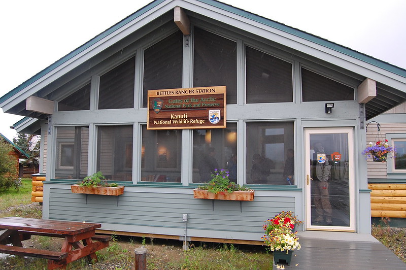
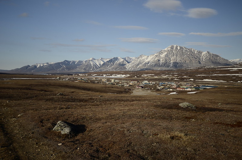
Bettles – This is one of the gateway towns for Gates of the Arctic, only reachable by flights in the summer (though it can also be reached by the park via a float trip, and there is an ice road to here in the winter). We saw a number of adventure vacation operations which used this area as a base. It is located about 30 miles north of the Arctic Circle and has a population of 13 according to the 2010 census (we saw one report that it has as many as 50 people living there in the summer due to seasonal employment). The park has a log cabin visitor contact station here, and the popular Bettles Lodge is nearby. Bettles has the added bonus of providing access by air taxi to Kobuk Valley National Park as well.
This is a photo of the Bettles Ranger Station:
Coldfoot – This is one of three towns on the Dalton Highway – it had a population of 10 in the 2010 census. The national park lies north and west of Coldfoot. There is an air taxi which can take you from Coldfoot into the park. The Arctic Interagency Visitor Center is found here. There is a motel and campground here, as well as two lodges nearby in Wiseman.
In order to drive from Fairbanks to Coldfoot or Wiseman, you will need to travel on the Dalton Highway. The Dalton Highway is a 415 mile “Haul Road” which begins around 80 miles from Fairbanks at mile 73 on Elliott Highway and heads north to the town of Deadhorse, which is located a few miles from Prudhoe Bay on the Beaufort Sea of the Arctic Ocean. Coldfoot is located at Mile Marker 175 of the Dalton Highway, and Wiseman is at Mile Marker 188. However, most rental car agencies do not allow you to drive there automobile on the Dalton Highway. The car rentals consider this to be off-road and specifically prohibit it. Artic Outfitters, Go North and Alaska Auto Rental are the three which we have seen which allow travel on this road. You will need to be prepared for the road and emergencies – there are limited amenities on the trip and the road is known for the damage it can cause to windshields and tires. You should have extra food, water, fuel, medical supplies, tires, emergency flares as well as a CB radio or satellite phone to call for help. There is no cell service for most of the road, with the road only getting its first cell tower in 2017 which provides coverage in a 15 mile radius around Coldfoot.
Anaktuvuk Pass – There are flights from Fairbanks to this remote village founded by the Nunamiut Eskimo. It was established in the 1950s because of its location along the caribou migration route. It is within the park on the north slope of the Brooks Range. There are flights from Fairbanks to Anaktuvuk Pass. The park has a ranger station here. The National Park Service says that you can hike into Gates of the Arctic from here.
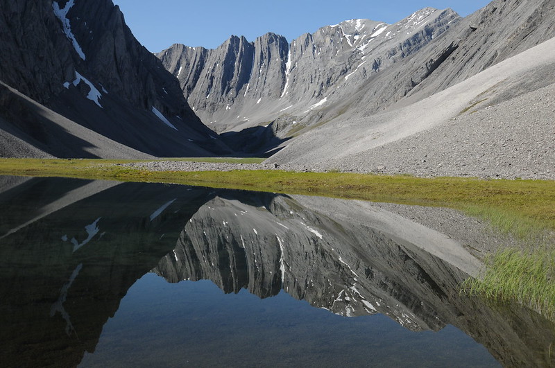
Arrigetch Peaks

This is a grouping of granite peaks in the Endicott Mountains of the central Brooks Range. They are a destination for flightseeing, guided backpacking trips as well as the occasional group of climbers. The Clymb called them “Alaska’s Last Great Climbing Wilderness.” They have also been described as a wild Yosemite. Circle Lake and Takahula Lake are popular spots for landing / taking off as part of the trip to Arrigetch, with Geadake Lake used by those who wish to packraft the Alatna River from the headwaters.
Gates of the Arctic Rivers
Six National Wild and Scenic Rivers flow through Gates of the Arctic. They are the Alatna River, John River, Kobuk River, Noatak River, North Fork Koyukuk River and Tinayguk River. The Wild and Scenic Rivers program was created by Congress in 1968 to preserve rivers with outstanding natural, cultural and recreational values in a free-flowing condition. There are around 200 rivers in the United States with this status, protecting more than 12,500 miles.
Noatak River
The Noatak River runs in Gates of the Arctic for 65 miles before continuing for another 265 miles in the national preserve that bears its name. It flows from its headwaters near Mt. Igikpak through the park into the Noatak National Preserve. Mt. Igikpak is the tallest mountain in Gates of the Arctic and the highest peak in the Schwatka Mountains region of the Brooks Range. It is listed as having an elevation of more than 8000 feet.
The river is designated as a wild river for 330 miles from its origins in the Gates of the Arctic to the Kelly River in the Noatak National Preserve. It is one of the longest designated wild rivers in Alaska. It also drains the largest mountain-ringed river basin in America.
The area is rich in wildlife including bears, wolves, moose, and Dall sheep. It is also popular for fishing, hiking and birding.
Kobuk River
The Kobuk River flows 380 miles from its origins in Gates of the Arctic National Park to its destination in the Kotzebue Sound, including a section through Kobuk Valley National Park. The 110 miles of the river from its headwaters in the Endicott Mountain to its exit from the national preserve are designated a wild river in the National Wild and Scenic River system. It is a popular float trip. The section below Walker Lake involves two sections of canyon with some Class 4 / Class 5 rapids that will require a portage.
Alatna River
The Alatna River flows for 83 miles through Gates of the Arctic National Park from its headwaters near the Continental Divide in the Endicott Mountains south and southeast past Arrigetch Peaks. For the length of its time in the park, it is designated a wild river in the National Wild and Scenic River system. It intersects with the Koyukuk River around 100 miles later near Allakaket. The Alatna River is popular for packrafting through the park, with a number of put in and take out spots along the way that allow visitors to enjoy the Arrigetch Peaks. Put in spots include Gaedeke Lake at the headwaters, Circle Lake and Takahula Lake with take out spots of Takahula Lake, Malamute Fork, and even floating to Allakaket.
Oolah Valley / Itkillik Preserve
Oolah Valley is a scenic valley in the Itkillik Preserve (a section of the Gates of the Arctic National Preserve that is northeast of the national park boundary) that has been called the Yosemite of the Arctic. The valley follows the Itkillik River, which flows north from the Endicott Mountains near Oolah Pass. It is a 220 mile long tributary of the Colville River.
The northeast preserve unit is approximately 330,000 acres, and the river and lakes of the Oolah Valley are the primary attractions to the preserve. The mountains rise 3000 to 4500 feet above the valley floor, which is two miles wide in the southern section to six miles wide in the north near Itkillik Lake. Access to the steep and narrow valleys of the Nanushuk River (center section of the preserve) and the Alapah Creek (western section) in the preserve are more difficult and thus see less people.
Chandalar Shelf can be used as a starting point for a trip to the Oolah Valley – we saw it suggested by a park ranger on their Facebook page. Chandalar Shelf is a flat valley at the headwaters of the North Fork of the Chandalar River. Oolah Pass utilizes the Kuyuktuvuk Creek Drainage to cross the Continental Divide – which requires crossing the Dietrich River near the Dalton Highway. It is about a 20 mile hike to reach the valley.
If Itkillik Lake is the destination for the start of your journey, we have seen Galbraith Lake off the Dalton Highway suggested as the starting point for a twenty mile hike to the valley.
There are also several lakes in the Oolah Valley accessible by float planes, including Oolah Lake and Itkillik Lake. Itkillik is the largest of the lakes in the valley, and Oolah is near the border of the national park.
Remember to take time to explore the side valleys, as half of the adventure at Gates of the Arctic is the discovery of unexpected beauty. You may just find Thunder Valley, the unofficial name of a valley that you won’t find on the NPS website. We saw several journeys showing off photographs of this scenic valley. If you look at their itineraries closely, you can figure out where it is located (as we did). However, we will keep this one to ourselves in order to keep it pristine for those are willing to undertake the effort to find it.
Walker Lake
Walker Lake is the largest lake in Gates of the Arctic National Park (12+ miles long with an average width of over a mile) and the outflows from the lake are one of the origins of the Kobuk River. The lake is a popular destination in the park due to its outstanding fishing, camping and the put-in for a journey down the Kobuk River. The lake is designated a national natural landmark and is a glacially carved lake.
Other Gates of the Arctic Lakes
Agiak Lake – This is a 1.5 mile long lake at the head of Agiak Creek nine miles south of Chandler Lake and about 30 miles west of Anaktuvuk Pass. It is popular fishing for arctic grayling and lake trout. Caribou frequent the area in August and the landscape contains historical drivelines of rock cairns used to herd caribou into the lake for hunting.
Amiloyak Lake – This is a 1.7 mile long lake and the headwaters of the Chandler River six miles southwest of Chandler Lake.
Chandler Lake – This is a large lake west of Anaktuvuk Pass which contains native inholdings within the boundaries of the park and can be accessed by float plane. Fishing is good for lake trout, arctic char and grayling
Circle Lake – This lake is a popular put in for hiking Arrigetch Peaks and packrafting the Alatna River.
Itkillik Lake – This is the largest lake in the Itkillik Preserve (about 3 miles long by 1 mile wide at its widest) in the northeast corner of the park, about a 20 mile hike from Gilbraith Lake. Reports are that it contains lake trout, char and grayling.
Florence Creek Lake – This lake is one mile northeast of the junction of the North Fork Koyukuk River with Florence Creek.
Kurupa Lake – This lake is the most important visitor access point in the northwest quadrant. It is three miles long with a high ridgeline separating it from its tributary lake. It also has a healthy population of lake trout, arctic char and round whitefish. It is the source of the Kurupa River which flows into the Colville River.
Lake Amitchiak – This lake is near the border with Noatak National Preserve below Lake Kipmik with outflows in the Rough Mountain Creek.
Lake Isiak – This is a 1.5 mile long glacial lake in the Noatak River Valley near the Noatak River and three kilometers from Lake Matcharak in the western section of the park.
Lake Kipmik – This is a scenic lake with a gravel beach and two inlets on the south side and an outlet on the northwest side which connects it to Lake Amitchiak and then to the Aniuk River by Mountain Creek.
Lake Matcharak – This lake is in the upper Noatak River valley and has been described as “full of northern pike”. A shoreline bluff yielded one of the most important archaeological collections in the Gates of the Arctic museum from a Paleo-Inuit camp. It is also a pickup for Noatak River float trips that involves a short carry of gear from the river to the beach.
Lake Omelaktavik – This lake is in the Noatak River valley south of the river.
Lake Selby – This is one of the more popular summer fishing lakes about 80 miles west of Bettles. It contains lake trout, pike and grayling. Narvak Lake is north of it.
Nutuvukti Lake – This lake in the Kobuk Preserve is six miles long and is located between two mountain ridges southeast of Walker Lake. It is home to lake trout, arctic grayling, arctic char, northern pike, and whitefish.
Oolah Lake – This lake is in the Oolah Valley near the Oolah Pass along the route of the Itkillik River.
Summit Lake – This is the source of the Itkillik River at the Continental Divide in the eastern section of the national park about 8 miles from the Itkillik Preserve.
Takahula Lake – This is a popular put in and take out spot for hiking the Arrigetch Peaks and packrafting in the Alatna River in the Endicott Mountains of the central Brooks Range.
Gates of the Arctic Fishing
Fish populations in the park include grayling, arctic char, dolly varden, and chum salmon. Grayling are found in many of the park’s rivers, and chum salmon spawn in the upper reaches of the Noatak River in the autumn. The National Park Service asks you to only take what you can immediately consume because the populations are susceptible to overfishing due to the low growth rates in arctic waters. In late summer/fall, sheefish can be caught in the upper reaches of the Kobuk River as they migrate into the river and spawn in the fall. Sheefish are a large whitefish that is a member of the salmon family.
Gates of the Arctic Caribou
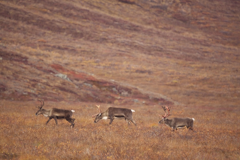
Caribou are large members of the deer family. They live in approximately 32 herds in Alaska. Herds of the caribou migrate through the Central Brooks Range twice a year, moving to the north for the summer and to the south in the winter. The largest herd, the Western Arctic Herd, and several others migrate through the park.
Gates of the Arctic Bears
There are grizzly bears and black bears in Gates of the Arctic, so proper precautions need to be taken including appropriate food storage and defensive aerosol sprays (bear spray). There has only been one fatal bear attack in the park, but there has been the occasional bear attack for one reason or another over the years. The population averages one brown bear for each 100 square miles, but they can be concentrated in the summer around rivers when salmon are running.
Busiest Months
The best time for backpacking is from mid-June to September. July through August is considered the best time for float trips. However, visitors need to be prepared for wet weather and cold temperatures at any time.
Weather:
It is best to be prepared for a variety of weather conditions due to the remote nature of the park and the possibility of rapid and unpredictable weather changes. In the summer, there can be large temperature differences between the heat of the day and the cold at night. In the winter, daytime temperatures routinely stay below 20 degrees.
Average Temperature (Monthly)
Forecast:
[wunderground location=”Coldfoot, AK” numdays=”4″ layout=”simple” showdata=”search,alert,daynames,highlow,pop,icon,text,conditions,date”]
Radar:
Camping:
There are no designated campsites within the Gates of the Arctic. Campsites are encouraged on gravel bars that are well above current water levels. Campers are also encouraged to move camp every 2-3 days to give the environment a chance to recover from your presence there. Also keep in mind that you are in bear country so locate your cooking/eating area at least 100 yards from your sleeping area and don’t store food and other odorous items in your sleeping area
Lodging in Fairbanks (Hours Away!)
Gates of the Arctic Lodging
Coldfoot / Wiseman Lodging
Coldfoot Camp, the Artic Getaway B&B or Boreal Lodging are all in this area along the Dalton Highway. Coldfoot Camp has free space to camp in the summer and an “Inn” that is composed of trailers once used to house workers building the pipeline which have been refurbished with two beds and a private bathroom with shower. Arctic Getaway offers log cabin rentals, while Boreal Lodging has four rooms in the main lodge and two separate cabins for rent. Access into the park from this area is usually by Coyote Air which uses the Coldfoot Airport as its headquarters and can provide transportation into the park by plane.
Iniakuk Lake Lodge
This lodge is a fly-in only resort that is located on the north end of Iniakuk Lake a few miles outside of Gates of the Arctic. It is reached by a 20 minute flight on a float plane from Bettles. Although the main lodge is located outside of the park, they maintain the Arrigetch Peaks Wilderness Cabin and the Caribou Cabin which are inside the park. The main lodge can serve as a launching point for day trips into the park
Bettles Lodge
This lodge on the south bank of the Koyukuk River is located a few miles from Bettles. It is a popular starting point for trips to Gate of the Arctic. The lodge was originally built in 1948.
Vacation Packages:
Shop:
Gates of the Arctic Passport Stamps
There are four locations where you can get your passport stamp for GAAR: Anaktuvuk Pass, Bettles Field, Coldfoot and Fairbanks. The Anaktuvuk Pass Visitor Center is the only passport stamp location actually located within the park boundaries, although it is surrounded by private land. Coldfoot Arctic Interagency Visitor Center. You can also get the stamp at the Fairbanks Alaska Public Lands Information Center, which is the only location which is open year round. However, you can reportedly only get the passport stamp for Kobuk Valley National Park at Kotzebue and Coldfoot – so if you will be planning a trip to both from Bettles (for example) you will need to run up to Coldfoot to get the Kobuk Valley stamp.
Frequently Asked Questions
Can you drive to Gates of the Arctic?
You can not drive into or through Gates of the Arctic. The only option which does not involve a flight into the park is to drive up the Dalton Highway from Fairbanks to the Coldfoot area and hike in. The visitor center for the park is located in Coldfoot, Alaska. It is called the Arctic Interagency Visitor Center, a parternship between NPS, BLM and Fish & Wildlife. It is open daily during the summer. Coldfoot had a population of 10 in the 2010 census and primarily serves as a truck stop on the Dalton Highway. Hiking into the park from Coldfoot would require a river crossing of the Middle Fork of the Koyukuk River, but Dalton Highway crosses the river a few miles north and it appears possible to walk into the park from Wiseman. Some or all of this land may be private property however. Wiseman is located just off Mile 189, about 14 miles north of Coldfoot, where there is a sign for the Wiseman Spur road for the three mile drive back to the town.
How many people visit Gates of the Arctic?
Only 10,000 to 12,000 people visit Gates of the Arctic National Park, making it one of the least visited national parks. In 2018, it iwas the least visited national park with just under 10,000 making the journey.
Why did the Gates of the Arctic become a national park?
The park protects the Brooks Range, undisturbed land of the Arctic Circle and the many wildlife in the area.
Nearby Parks
Noatak National Preserve
This national preserve stretches from Gates of the Arctic National Park on the east to nearly reach Cape Krusenstern National Monument on the west. It is located north of the Arctic Circle and is America’s largest protected mountain-ringed river basin – the Noatak River flows throguh it. Access to the park is generally by air taxi and its headquarters is in Kotzebue.
Arctic National Wildlife Refuge
This is the largest national wildlife refuge in the United States with nearly 19.3 million acres. It sits in the northeast corner of Alaska stretching south from Beaufort Sea and the Artic Ocean and west from the border of Alaska and Canada. At its easternmost point, it is separated from Gates of the Arctic National Park by a strip of land several miles including the Dalton Highway.
American Samoa
Arches
Badlands
Big Bend
Biscayne
Black Canyon
Bryce Canyon
Canyonlands
Capitol Reef
Carlsbad Caverns
Channel Islands
Congaree
Crater Lake
Cuyahoga Valley
Death Valley
Denali
Dry Tortugas
Everglades
Gates of the Arctic
Glacier Bay
Glacier
Grand Canyon
Grand Teton
Great Basin
Great Sand Dunes
Great Smoky Mountains
Guadalupe Mountains
Haleakala
Hot Springs
Hawaii Volcanoes
Hot Springs
Isle Royale
Joshua Tree
Katmai
Kenai Fjords
Kings Canyon
Kobuk Valley
Lake Clark
Lassen Volcanic
Mammoth Cave
Mesa Verde
Mount Rainier
North Cascades
Olympic
Petrified Forest
Pinnacles
Redwood
Rocky Mountain
Saguaro
Sequoia
Shenandoah
Theodore Roosevelt
Virgin Islands
Voyaguers
Wind Cave
Wrangell-St. Elias
Yellowstone
Yosemite
Zion