Utah”]
Utah’s Largest National Park.
Canyonlands National Park
Canyonlands National Park is Utah’s largest national park and a popular place for whitewater rafting, mountain biking and backpacking. The Colorado River has carved deep canyons through the park.
Open / Close / Reopening Status of Canyonlands National Park due to Coronavirus (COVID-19)
Please check the national park website for the latest:
More information about Canyonlands
Last Updated: June 12, 2021
Popular Areas
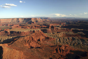
Island in the Sky: The area on top of a 1500 foot mesa with a scenic drive that has twenty miles of paved roads and pullouts with spectacular panoramic views of Canyon Country. This section of the park receives the most visitors.
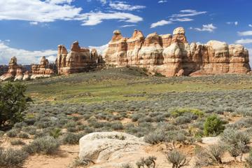
The Needles: A remote southeast section of the park with colorful spires of Cedar Mesa Sandstone. There are sixty miles of trails for overnight backpacking trips in this section of the park. The Squaw Flat Campground is in the area with 26 first come, first served campsites.
The Maze District: The most remote part of the park is known for its dead-end canyons. Only 2,000 people per year pass through this area and most do so with a jeep. A high clearance four wheel drive vehicle is required on backcountry roads in this area, which presents considerable risk of damage. In 2008, Backpacker declared it America’s most dangerous hike. It borders Glen Canyon National Recreation Area.
Horseshoe Canyon: Home to some of the most significant rock art in North America. The best known panel is the Great Gallery, which is reached by a seven mile roundtrip hike.
Cataract Canyon: Cataract Canyon beings where the Green and Colorado Rivers meet. It is considered one of the best rafting trips in the country. The 14 miles of whitewater rapids on the Colorado River through Cataract Canyon contains numerous stretches of Class III-V rapids.
White Rim Trail – A 100 mile loop on a jeep road that is a popular 3-5 day trip for mountain bikers. There are ten camping areas along the trail but no potable water so most bicyclists use a support vehicle with four-wheel drive.
History
Evidence shows humans first visited Canyonlands about 10,000 years ago, when nomadic hunter-gatherers depended on wild plants and animals to survive. They appear to have traveled through the area, perhaps seasonally, not leaving many artifacts or structures. They did leave behind the rock art found on the cliff walls of Horseshoe Canyon. About two thousand years ago, domesticated animals and plants were the main food source. Ancestral Puebloans and Fremont people grew maize, beans, and squash, and kept domesticated dogs and turkeys. They lived year-round, in villages like the one preserved at Mesa Verde National Park. Growing populations at Mesa Verde led to searches for new land in the area, and large groups moved to the Needles District near Salt Creek. Structures remain, such as the one at Roadside Ruin in the Needles, or the Aztec Butte on the Island in the Sky. Changing weather patterns made agriculture increasingly difficult, and the ancestral Puebloans left the area for present-day New Mexico and Arizona.
After they left, Ute, Paiute, and Navajo people moved in, and their decendants remain today. They were also hunter-gatherers, and did not extensively explore the Canyonlands area. Early European settlers included the Spanish Fathers Escalante and Dominguez, seeking California, as well as French and American trappers and traders, searching for beaver and otters. Official exploration began in 1869, when Maj. John Wesley Powell lead an expedition from Wyoming to the Grand Canyon, with an inspiring stop in what is now Canyonlands. In 1855, Mormons set up a mission in what is now Moab. Conflicts with the Utes led them to resettle in southeast Utah, where they became farmers, prospectors, or ranchers. The ranchers used the area of Canyonlands as a winter pasture.
The area was advocated toward National Park status by the superintendent of Arches, and the park was established in 1964.
Entrance fees
An entrance fee of $15 for motorcycles and $25 for private, noncommercial vehicles is charged at entry. The passes are good for seven days. The park offers an annual pass for $50 that is good for 12 months from the purchase date, and also grants access to Arches National Park. The national park pass ($80), senior pass ($10) and other national park passes are accepted at Canyonlands National Park.
Busiest Months (Percentage of Annual Visits)
Rafting:
There are about a dozen approved concessioners to guide you on a whitewater rafting trip through the park. Offered trips range from one day to five or more days.
Hiking Trails:
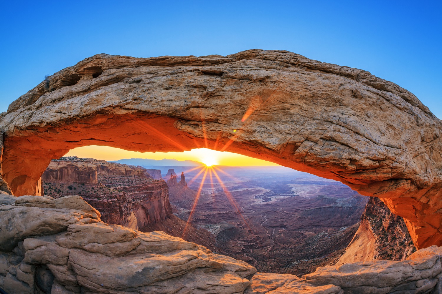
Mesa Arch Trail – A popular .6 mile loop with spacious trailhead parking. The arch faces east, so it is a popular place to photograph the sunrise.
Upheaval Dome – A one mile roundtrip hiek to reach the first overlook of this geological attraction, and participate in the debate about whether it was formed by a meteor – or another manner.
Rock Climbing:
Fishing Canyonlands
Catfish and carp are abundant in the Colorado and Green Rivers.
Recent Bird Sightings
Current Astronomy Chart
Weather:
Average Temperature (Monthly)
Forecast:
[wunderground location=”Moab, UT” numdays=”4″ layout=”simple” showdata=”search,alert,daynames,highlow,pop,icon,text,conditions,date”]
Radar:
Camping:
There are two campgrounds in the Canyonlands – one at The Needles and one at Island in the SKy. Willow Flat Campground has a dozen campsites in Island in the Sky. If you stay here, take the short walk to the Green River overlook at sunset. Squaw Flat Campground is in The Needles. Due to its remote location, the 26 campsites here fill up fast during the busy season.
Backcountry camping requires a permit. Mountain bikers and four-wheel drivers must stay in designated campsites. Backpackers in The Needles must also stay in designated campsites. Backpackers in The Maze or Island in the Sky can choose their locaiton within at-large zones.
Some Hotels and Other Lodging Options:
Moab is a small town (population 5,000) along U.S. Route 191 just to the south of Arches National Park that contains a variety of hotels and motels. It is located about 30 minutes west of Canyonlands National Park.
Vacation Packages:
Roundtrip Flights to Salt Lake City
[tp_in_our_city_fly_shortcodes destination=SLC title=”” limit=15 paginate=false stops=1 one_way=false off_title=true subid=”” currency=”USD”]
Can you drive through Canyonlands National Park?
Grand View Point Road and Upheaval Dome Rd provide visitors access to the scenic overlooks of Island in the Sky in Canyonlands via about twenty miles of roads. Utah State Route 211 allows visitors to drive through a short six or seven mile section of the Needles with access to connected paved roads. High clearance, four wheel drive vehicles provide visitors with additional access to the park districts.
How long does it take to see Canyonlands National Park?
The national parks offer adventures for those who have a day, a week or even longer to explore. Canyonlands is such a park. If you have a half day, you can drive through Island in the Sky, stop in at the visitor center and take short hikes to Mesa Arch and Grand View Point. If you have the time for a second day, you can add a trip to The Needles (which is not accessible directly from Island in the Sky) and a day hike there. If you are prepared for a rugged adventure and wish to also include a trip to the remote third district in the Canyonlands – the Maze – then you should have about a week.
How far is Arches National Park from Canyonlands National Park?
The Island in the Sky Visitor Center is approximately 35 minutes from the Arches Visitor Center. Both visitor centers are located near the entrances of the parks. It can be longer to drive between locations inside the two parks. For example, it is at least an hour between Delicate Arch in Arches National Park and Mesa Arch in Canyonlands National Park.
How far is Needles from Moab?
The Needles District Visitor Center is located about 90 minutes southwest of Moab. It is reached by taking US 191 south for 40 miles and then traveling west on UT 211. 211 is the only road into or out of the Needles.