Alaska”]
Alaskan sand dunes and caribou migration.
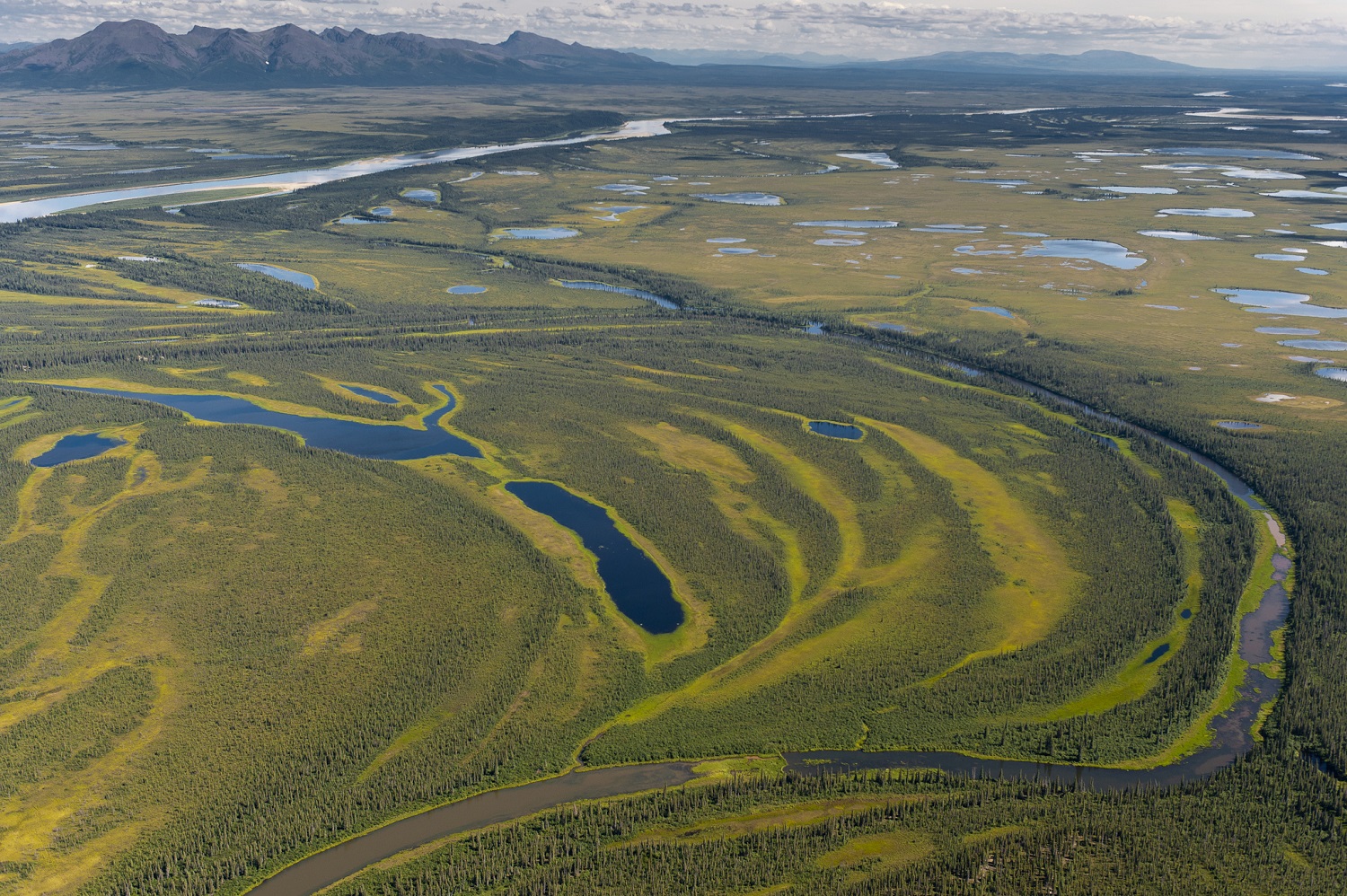
Kobuk Valley National Park
This 1.7 million acre national park is located in northwestern Alaska 25 miles north of the Atlantic Circle. It is known for its approximately 20,500 acres of sand dunes and the migration of the caribou herd every spring and fall. The park also protects the evidence of North America’s first inhabitants, with evidence of caribou hunting in the area at Onion Portage dates back at least 9,000 years.
There are no roads, trails, gift shops, campgrounds or parking facilities within the park. The visitor center and park headquarters are located in Kotzebue outside the park. Access to the park is by air.
Although north of the Arctic Circle, the park is bisected by the Kobuk River and teems with wildlife activity during the short summer. The park lies at the junction of the boreal forest with the arctic tundra.
Open / Close / Reopening Status of Kobuk Valley National Park due to Coronavirus (COVID-19)
More information on Kobuk Valley
Last Updated: May 2, 2020
Seasonal Ranger Stations
There is a seasonal ranger station at Kallarichuk along the Kobuk River, at the west end of the park. The Onion Portage area also has a seasonal ranger station on the eastern border of the park along the Kobuk River.
Onion Portage Archaeological Site
This archaeological site was identified in 1940 and contains nine layers of artifacts dating back to 6500 BC. Thousands of artifacts have been found at this historical campsite, which was one of the first sites discovered in Alaska which date back more than 5000 years.
Onion Portage is located on the northern banks of the Kobuk River. Onion Portage was added to the National Register of Historical places in 1972 and was made a National Historic Landmark District in 1978. The Giddings Cabin, which has been preserved by the National Park Service, and was used by the discoverer of the site J. Louis Giddings in 1964, is on the site.
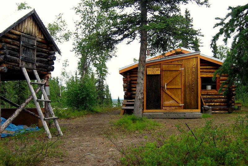
Photo Credit: Western Arctic National Parklands
The site is a famous hunting ground for local residents. Caribou killed by hunters during their crossing of the Kobuk River float downstream and wash ashore here. There is a wide bend forming a peninsula and a gravel shore. The site is named for the wild onions that grow here in the summer.
Kobuk Valley Sand Dunes
The Kobuk Valley National Park sand dunes are “America’s most obscure desert” according to the Sierra Club.
The movement of ancient glaciers against the mountains during the last Ice Age created the sand which has been carried to the Kobuk Valley by wind and water. Much of the southern portion of the Kobuk Valley is now covered by sand, left behind when the glaciers retreated.
There are three sand dunes in the area, with the Great Kobuk Sand Dunes occupying 25 square miles and some dunes reaching to 100 feet tall. These are the largest active sand dunes in the Arctic.
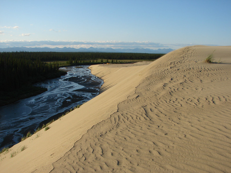
Average high temperatures in the Great Kobuk Sand Dunes in the summer are usually in the 60s, with some days into the 70s or 80s. However, the temperature can reach 100 on some days in the summer there despite the fact that it lies north of the Arctic Circle.
Kobuk Valley also has two other active sand dunes: the Little Kobuk Sand Dunes and the Hunt River Dunes. The Little Kobuk Sand Dunes are in the southeast corner of the park to the east of the Great Kobuk Sand Dunes. The Hunt River Dunes are located on the south bank of the Kobuk River at the mouth of the Hunt River.
Kobuk Valley National Park Caribou
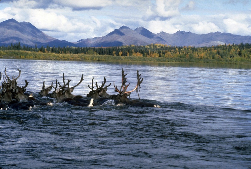
Photo Credit: Western Arctic National Parklands
The Western Arctic Caribou Herd, the largest in the United States, passes through the park twice a year on its migration, leaving millions of hoof prints on the sand. The caribou typically summers at Noatak and winters at Selawik.
The Western Arctic Herd (WAH) ranges over a territory of 157,000 square miles and has one of the longest terrestrial migrations of any land animal. They can walk over 2,000 miles in a single year. In comparison, the Sengeti migration of wildebeest and other animals is around 1800 miles a year.
The dates of the caribou migration vary from year to year, you are probably looking at April from the trek northward to the calving grounds and September (or later) for the migration south to the wintering grounds. There is not too much online about timing the caribou migration of the Western Arctic Herd to meet them in the park. However, we have seen data that the herd is usually in the calving grounds for birthing north of the Noatak River from late May to mid-June, so we know that it must happen in the April to early May period. There is typically ice on the river until April and it can be as late as May when the river ice breaks up / thaws. It turns out that research indicates caribou herds across North America start spring migration at around the same time ocean-driven climate cycles.
For the fall migration southward, we have seen online references to the annual migration being delayed two to six weeks in recent years. The caribou tagging project at Onion Portage as the caribou cross the Kobuk River at one time happened in late August but the crossing of the Noatak River as the herd moves south has been delayed in recent years, not happening until late September or even early October. We have seen some references to this migration happening even later – not until late October or early November.
So what have we learned? If your goal is to see the caribou, you will need to be flexible either in the destination of your journey or the timing of the trip. However, if you do manage to time it to be at Onion Portage for the annual crossing, you will witness a historic event. Alaska inhabitants have been gathering at Onion Portage for the crossing of the caribou for thousands of years, hunting there to ensure their survival of the winter. The annual fall hunt has made it a key archaeological site.
Kobuk Locoweed
This flowering herb in the pea family is only found in Kobuk Valley National Park. It lives on the slopes of the Great Kobuk Sand Dunes and produces purple flowers in late June and July. It grows to a height of 30 cm
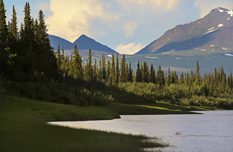
Mountain Ranges
Baird Mountains – This mountain range is located between the Kobuk River and Noatak Rivers in Alaska, about sixty miles east of Kotzebue. It is named for Spencer Fullerton Baird, the second Smithsonian Secretary from 1878 to 1887. It is located on the north side of Kobuk Valley.
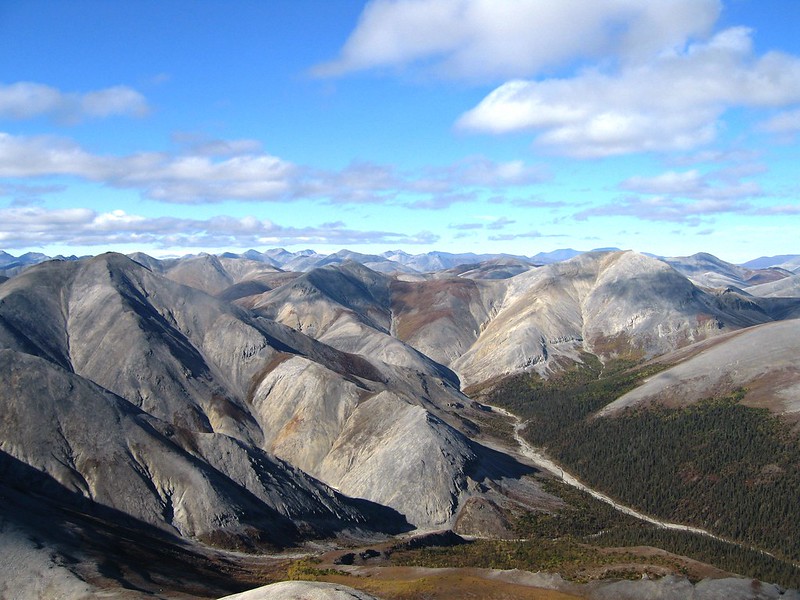
Photo Credit: Western Arctic National Parklands
Waring Mountains – This is a group of mountains or high ridges at the southern end of Kobuk Valley and the northern end of Selawik Valley.
Kobuk River
The Kobuk River flows through the southern section of the park for 61 miles as part of its 280 mile long journey starting in Gates of the Arctic National Park and flowing through Kobuk Valley National Park and Selawik National Wildlife Refuge before reaching Hotham Inlet of the Kotzebue Sound and the Chukchi Sea. Most of the major tributaries to the Kobuk River are flowing from the southern Brooks Range and the Baird Mountains, with a few tributaries flowing north to the river from the Waring Mountains.
The Kobuk is known for its fishing, which include the sheefish, arctic grayling, northern pike and other species. The sheefish migrates through the park to its spawning grounds in the upper reaches of the river. The sheefish is a large whitefish that may grow to weigh up to 60 pounds and has become a popular sport fish.
Salmon River
The Salmon River flows for 70 miles in the park from its origins on Mt. Angayukaqsraq, the highest peak in the national park, to the Kobuk River. It has been designated a wild river in the national wild and scenic rivers system. Its watershed is entirely above the Arctic Circle, and it is the most northern of the 19 streams, 13 creeks and 6 rivers in Alaska that are named for the popular gamefish. The Salmon River is known for its large salmon runs, which are composed of chum and pink salmon, but it also support a grayling fishery.
The Salmon River starts near the northern border of the park flowing north for a brief period of time before turning west and then south to the Kobuk River. It meets the Kobuk River in the southwest corner of the park as the Kobuk River flows toward Kallarichuk (a seasonal ranger station on the western border) and Kiana (a community outside of the park). In between, it rushes through a steep valley, rolling hills and then lowlands while it moves through various environments ranging from arctic tundra to a boreal forest.
Most float trips of the Salmon River take a flight to the Anaktok-Sheep Creek confluence where a plane can land on a gravel bar. It can be reached by a flight from Kotzebue or Kiana – it is a 30 minute flight from Kiana. From there, it is 50 miles to the intersection with the Kobuk River and another 48 miles to the first take out in Kiana. The Kobuk River departs the national park for the Selawik National Wildlife Refuge about 20 miles from the confluence of the Salmon River with the Kobuk River. The village is on the right (north side) a few miles after the Squirrel River confluence. The next take out after Kiana is Noorvik which is another 25 miles on the river (2 days).
Kobuk Valley National Park Fishing
Grayling and pike are available year round in the park, with sheefish, chum salmon and pink salmon running in the river in the fall. The National Park Service has also noted that there are Dolly Varden in the area rivers. Anglers are required to have a fishing license and follow state fishing regulations.
How to Get to Kobuk Valley National Park
Kotzebue
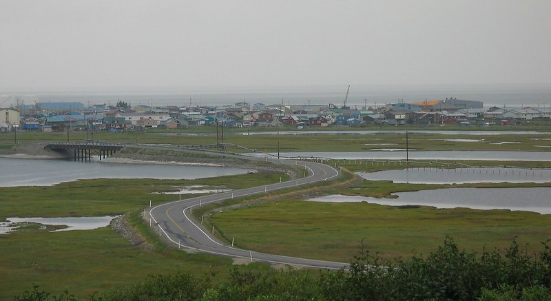
Kotzebue, with a population of around 1000, sits on the Baldwin Peninsula above the Arctic Circle. Hiking, birding and fishing are popular activities in this gateway town to Kobuk Valley National Park. The Northwest Arctic Heritage Center, the visitor center for the national park, is also located here. The Noatak, Selawik and Kobuk Rivers drain into the Kotzebue Sound near Kotzebue. The Kotzebue airport can be reached by a flight on Alaska Airlines from Anchorage. You can charter an authorized air taxi from there.
Bettles
This is one of the gateway towns for Gates of the Arctic, only reachable by flights in the summer (there is an ice road to here in the winter). It is located about 30 miles north of the Arctic Circle and has a population of 13 according to the 2010 census (we saw one report that it has as many as 50 people living there in the summer due to seasonal employment). Bettles also provides access by air taxi to Kobuk Valley National Park in addition to Gates of the Arctic.
Ambler, Alaska
This is a small community upstream of the Kobuk Valley with a population of around 250 people. Visitors can fly into Ambler, Alaska via an air taxi and take a boat into the park. The Kobuk River Lodge is located in Ambler.
Preparations for Your Kobuk Valley Vacation
Kobuk Valley is essentially a wilderness area with no trails or roads. Preparations and the ability to self-rescue are necessary for trips into the park. Emergencies may happen, and help may be days away.
Visitors to the park should at a minimum carry a satellite phone as well as the numbers for a friend, their air taxi and the park rangers. Cell phones do not work in Kobuk Valley National Park. Visitors may also want to carry a Personal Locator Beacon (PLB) for additional protection.
There are both brown bears and black bears in the park. Park visitors should also bring bear resistant food containers in addition to bear spray.
Protection against insects is also necessary. Bug jackets, head nets and insect repellant will make your trip through the park more pleasant. Mosquitos are bad in June and July, and black flies are common in August.
Bring a topographical map, compass, GPS unit and extra batteries. Warm layers in a breathable fabric (not cotton) as well as raingear. A four season tent for multi-day trips, and for day trips a thermal emergency blanket for a temporary shelter. Extra food and gear as well in case your air taxi pickup is delayed due to bad weather.
Weather Forecast:
[wunderground location=”Ambler, AK” numdays=”4″ layout=”simple” showdata=”search,alert,daynames,highlow,pop,icon,text,conditions,date”]
Average Temperature (Monthly)
Radar:
Some Hotels and Other Lodging Options:
There is no established Kobuk Valley lodging. There are several lodges in nearby communities that are the launching point for day trips and multi-day adventures into the park.
Nullagvik Hotel is located in Kotzebue and has 71 guest rooms and seven suites for guests. It was originally established in 1975 and the current hotel was built in 2011.
Kobuk River Lodge in Ambler was founded over thirty years ago and offers accommodations for up to ten guests. They offer guided day trips and camping in Kobuk Valley National Park. Onion Portage is located ten miles down the river from Ambler, and the Great Kobuk Sand Dunes are 46 river miles from Ambler.
Bettles Lodge is located in the village of Bettles thirty-five miles north of the Arctic Circle. It is reached by air taxi and is a popular starting point for trips to Gates of the Arctic National Park. The lodge was originally built in 1948.
Kobuk Valley Passport Stamps
There are two locations where you can get your passport stamp for KOVA: Coldfoot and Kotzebue. Kotzebue is the park’s visitor center which is located at the Northwest Arctic Heritage Center, and is open year round. The Coldfoot location for stamps is the Arctic Interagency Visitor Center, which is only open in the summer. If you will be planning a trip to both from Bettles (for example) you will need to run up to Coldfoot to get the Kobuk Valley stamp.
Vacation Packages:
Shop:
Nearby Parks
Noatak National Preserve
This national preserve stretches from Gates of the Arctic National Park on the east to nearly reach Cape Krusenstern National Monument on the west. It is located north of the Arctic Circle and is America’s largest protected mountain-ringed river basin – the Noatak River flows through it. Access to the park is generally by air taxi and its headquarters is in Kotzebue. It borders Kobuk Valley to the north.
Selawik National Wildlife Refuge
The two million acres of this wildlife refuge, managed by the US Fish and Wildlife Service, straddle the Arctic Circle at the intersection of the boreal forest and the arctic tundra, where the free-flowing rivers and vast wetlands have abundant wildlife, fish and birds.
Gates of the Arctic National Park
Gates of the Arctic National Park and Preserve is the northernmost national park in the United States, located entirely within the Arctic Circle. It is one of the least visited national parks with no roads inside its boundaries. It is primarily composed of the Brooks Range, an extension of the Rocky Mountains in Alaska. It contains six rivers on the national wild and scenic rivers list.
Cape Krusenstern National Monument
This national monument is located northwest of Kotzebue protecting over 600,000 acres near the Alaska coast. It has 70 miles of shoreline on the Chukchi Sea and world class birding in the summer.
American Samoa
Arches
Badlands
Big Bend
Biscayne
Black Canyon
Bryce Canyon
Canyonlands
Capitol Reef
Carlsbad Caverns
Channel Islands
Congaree
Crater Lake
Cuyahoga Valley
Death Valley
Denali
Dry Tortugas
Everglades
Gates of the Arctic
Glacier Bay
Glacier
Grand Canyon
Grand Teton
Great Basin
Great Sand Dunes
Great Smoky Mountains
Guadalupe Mountains
Haleakala
Hot Springs
Hawaii Volcanoes
Hot Springs
Isle Royale
Joshua Tree
Katmai
Kenai Fjords
Kings Canyon
Kobuk Valley
Lake Clark
Lassen Volcanic
Mammoth Cave
Mesa Verde
Mount Rainier
North Cascades
Olympic
Petrified Forest
Pinnacles
Redwood
Rocky Mountain
Saguaro
Sequoia
Shenandoah
Theodore Roosevelt
Virgin Islands
Voyaguers
Wind Cave
Wrangell-St. Elias
Yellowstone
Yosemite
Zion