
Bryce Canyon National Park is a popular place for a day hike starting from the canyon rim and descending into the Bryce Amphitheater or another section of the canyon. Family friendly hikes for all ages are also available at Mossy Cave and Rainbow Point.
Rim Trail
This frontcountry trail is a popular day hike which extends for 5.5 miles (one way) from Fairyland Point to Bryce Point. It offers views of the Bryce Amphitheater and permits travel along the canyon rim between the popular viewpoints including Sunrise Point, Sunset Point and Inspiration Point. The section from Inspiration Point to Bryce Point is closed during winter.
Mossy Cave Trail
Mossy Cave is an easy, one mile out and back trail in the northern section of the park through Water Canyon that begins from an elevation of 6832 feet. This is a family friendly trail offering a view of hoodoos without having to descend 1000 feet into the canyon. The trailhead is located on State Route 12 about four miles past Highway 63 on the drive to Tropic. The right fork on the trail leads to a waterfall while the left fork leads to the cave.
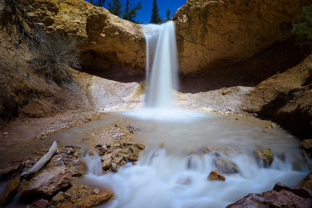
The water flowing from the East Fork of the Sevier River travels through here as part of an irrigation ditch known as the Tropic Ditch which was dug in the late 19th Century by Mormons in the area to provide water to Tropic and Cannonville.
Queens Garden Trail
This 1.8 mile trail starting from Sunrise Point is considered the easiest descent from the rim into the canyon. A short spur trail takes hikers to the hoodoo known as Queen Victoria.
Navajo Loop Trail
The Navajo Trail descends from Sunset Point into the Bryce Amphitheater. The Wall Street section of the loop is frequently closed during winter due to the risk of rockfalls – caution should be exercised at other times as well. In total, the loop is 1.3 miles. For a longer loop, it can be combined with the Queens Garden Trail.
Fairyland Loop Trail
This is an 8 mile day hike through the northern section of Bryce Canyon which typically takes 4-5 hours to complete. It begins at Fairyland Point, passes a short spur trail for the Tower Bridge, and ascends to connect to the Rim Trail near Sunrise Point.
Peekaboo Loop Trail
A 5.2 mile loop considered strenuous due to the length and rapid elevation change. The trail is shared by hikers with horse/mule riders.
Hat Shop Trail
A moderately difficult down and back trail starting at Bryce Point which descends to a cluster of hoodoos known as the Hat Shop. It traverses the first 2 miles of the Under-the-Rim Trail with a descent and then climb of 980 feet.
Sheep Creek and Swamp Canyon Loop
This is a 4.6 mile hike of moderate difficulty from the Swamp Canyon viewpoint at Mile 6 of the Scenic Drive that combines the Swamp Canyon Connecting Trail, a section of the Under-the-Rim Trail and the Sheep Creek Connecting Trail.
Under the Rim Trail
A difficult 23 mile (one way) backpacking trail between Bryce Point and Rainbow Point. There are eight backcountry camping sites along the way. A permit can be obtained for overnight stays at the Visitor Center. There are several connecting trails in the park for those who wish to include a section of this trail in a shorter hike.
Riggs Spring Loop Trail
A popular trail for moderate hiking and backcountry camping that departs from Yovimpa Point / Rainbow Point in the southern section of the park. It is 8.5 miles with an elevation change of 2248 feet from the high point to the low point at Riggs Spring. The trail is typically completed in two days with visitors stopping at one of the backcountry campsites along the way.
Bristlecone Loop Trail
An easy and short one mile lollipop loop hike through the subalpine fir forest departing from the picnic area at the Rainbow Point parking lot. It remains entirely above the canyon rim on the hike. The federally protected Bristlecone Pines along the trail can be 1800 years old – they only grow on certain rocky slopes at precise elevations in six states. They are different from most pines in that can retain their needles as long as 40 years rather than dropping them every few years. The trail also has viewpoints for the canyon and hoodoos along the way with a sweeping vista at the end.